
Interstate 65 in Indiana
From Wikipedia, the free encyclopedia
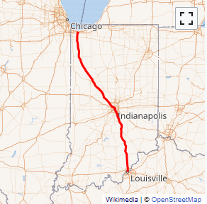
Interstate 65 (I-65) in the U.S. state of Indiana traverses from the south-southeastern Falls City area bordering Louisville, Kentucky, through the centrally located capital city of Indianapolis, to the northwestern Calumet Region of the Hoosier State which is part of the Chicago metropolitan area. The Indiana portion of I-65 begins in Jeffersonville after crossing the Ohio River and travels mainly north, passing just west of Columbus prior to reaching the Indianapolis metro area. Upon reaching Indianapolis, the route alignment of I-65 begins to run more to the northwest and subsequently passes Lafayette on that city's east and north sides. Northwest of there, in west-central Jasper County, the route again curves more northward as it approaches the Calumet Region. Shortly after passing a major junction with I-80 and I-94, I-65 reaches its northern national terminus in Gary at I-90 which is carried on the Indiana East\West Toll Road. I-65 covers 261.27 miles (420.47 km) in the state of Indiana. This is one of the principal interstate highways that cross the state, and, more specifically, intersect at the city of Indianapolis, that has given the state the nickname of \...
Full Wikipedia TopicI-65 IN Exits
Highway I-65 runs South to North with exit numbers starting at the southern most exit of each state or province.
Lodging Fuel Food Vehicle Shopping Entertainment/Tourist Medical Assistance Police Fire Pets Bank/ATM