
Interstate 35 Summary
From Wikipedia, the free encyclopedia
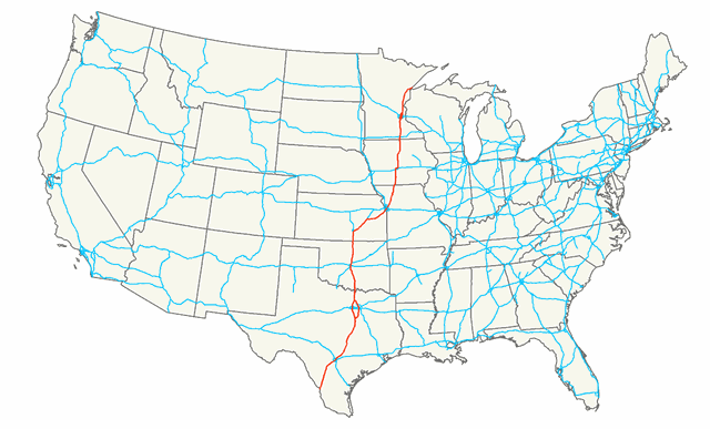
Interstate 35 (I-35) is a major Interstate Highway in the central United States. As with most interstates that end in a five, it is a major cross-country, north-south route. It stretches from Laredo, Texas, near the Mexican border to Duluth, Minnesota, at Minnesota State Highway 61 (MN 61, London Road) and 26th Avenue East. The highway splits into I-35E and I-35W in two separate places, the Dallas\Fort Worth metroplex in Texas and at the Minnesota twin cities of Minneapolis\Saint Paul.
At 1,568 mi (2,523 km), Interstate 35 is the ninth-longest Interstate Highway following I-94, and it is the third-longest north-south Interstate Highway, following I-75 and I-95. Even though the route is generally considered to be a border to border highway, this highway does not directly connect to either international border. I-35's southern terminus is a traffic signal in Laredo, Texas, just short of the Mexican border. Travelers going south can take one of two toll bridges across the Rio Grande and the border, either straight ahead into the Juarez-Lincoln International Bridge, or via I-35 Business through downtown Laredo into the Gateway to the Americas International Bridge. To the north, I-35 terminates in Duluth, Minnesota, with connections to Canada from the Interstate's terminus via MN 61 to Grand Portage, or north to the border at International Falls, Minnesota via U.S. Route 53 in Duluth.
In addition to the Dallas-Fort Worth and Minneapolis-Saint Paul areas, the major cities that I-35 also connects to include (from south to north) San Antonio; Austin, Texas; Oklahoma City; Wichita; Kansas City; and Des Moines....
I-35 States/Provinces
This highway passes through multiple states or provinces. Each is broken out sepeperatly in these listings.