
Interstate 20 Summary
From Wikipedia, the free encyclopedia
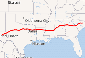
Interstate 20 (I\u201120) is a major east\west Interstate Highway in the Southern United States. I\u201120 runs 1,539 miles (2,477 km) beginning near Kent, Texas, at I-10 to Florence, South Carolina, at I-95. Between Texas and South Carolina, I\u201120 runs through northern Louisiana, Mississippi, Alabama, and Georgia. The major cities that I-20 connects to include (from west to east) Fort Worth, Texas; Dallas, Texas; Shreveport, Louisiana; Jackson, Mississippi; Birmingham, Alabama; Atlanta, Georgia; Augusta, Georgia; and Columbia, South Carolina.
From its terminus at I\u201195, the highway continues about 2 miles (3.2 km) eastward into the city of Florence as Business Spur 20.
...
I-20 States/Provinces
This highway passes through multiple states or provinces. Each is broken out sepeperatly in these listings.