
Interstate 19 Summary
From Wikipedia, the free encyclopedia
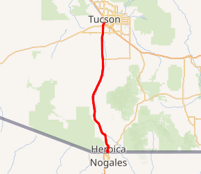
Interstate 19 (I-19) is a north\south Interstate Highway located entirely within the U.S. state of Arizona. I-19 travels from Nogales, roughly 300 feet (91 m) from the Mexican border, to Tucson, at I-10. The highway also travels through the cities of Rio Rico, Green Valley, and Sahuarita.
Having a total length of just over 63 miles (101 km), I-19 is the sixth-shortest primary (two-digit) Interstate Highway in the contiguous 48 states, where only I-97, I-86 (western), I-14, I-11 (which is set to replace most of, if not all of I-19 in the future) and I-2 are shorter.
While the highway is short, it is a very important corridor, serving as a fast route from Tucson and Phoenix (via I-10) to the Mexican border. The highway is a portion of the United States section of the CANAMEX Corridor, a trade corridor that stretches north from Mexico across the United States to the Canadian province of Alberta....
I-19 Exits
Highway I-19 runs South to North with exit numbers starting at the southern most exit of each state or province.
Lodging Fuel Food Vehicle Shopping Entertainment/Tourist Medical Assistance Police Fire Pets Bank/ATM